Scrip, Homesteads, and the Divergent Costs of Soil in Township 46
Introduction
In my previous post, I detailed how my Norwegian ancestors, the Bragers, acquired over 600 acres of Saskatchewan prairie for a few $10 fees and three years of labor.¹ It was a clear, accessible path to building land equity. But that is only half of my family’s story. On the other side of my tree, my Métis ancestors—the Birds and Cromarties—were navigating a radically different reality.² They didn’t receive “free” land; they were forced into the Scrip system—a bureaucratic maze that required them to “buy” back a seat at the table in their own ancestral territory.³ By comparing their journey to the Bragers, we see a collision of two systems in the very same neighborhood, where the rules of the soil depended entirely on who was standing on it.
Part 1: The Neighborhood Map (Townships 46 & 46A)
In the early 1900s, the Hagen/Birch Hills district was a patchwork of two completely different Canadian realities.⁴ The map reveals that my two families were living as direct neighbors, but under completely different legal definitions. While the Bragers were “proving up” their immigrant homesteads, the Birds and Cromarties were anchoring themselves to a family block just a few miles away:⁵
- The Homesteader (Brager): My grandfather, Ingvald Brager, held SE-8-46-25-W2.¹
- The Métis Hub (Birds & Cromarties):
- William Bird Sr. (2nd Great-Grandfather) held NW-4-46-25-W2.⁶
- John Cromartie (Great-Grand-Uncle) held NE-12-46-25-W2.⁷
- William George Cromartie (Great-Grand-Uncle) held SE-12-46-25-W2 and NE-1-46-25-W2.⁸
- William Edward Cromartie (Great-Grand-Uncle) held SW-12-46A-25-W2.⁹
Summary of the Neighborhood Comparison
| Family Member | Legal Description | Acquisition Method | The “Price” Paid |
| Ingvald Brager | SE-8-46-25-W2 | Standard Homestead | $10 & 3 years labor |
| William Bird Sr. | NW-4-46-25-W2 | Métis Settlement | Scrip & Loss of Ancestral Title |
| Wm. Edward Cromartie | SW-12-46A-25-W2 | Fractional Township (Former Reserve) | Scrip & Paper Affidavits |
| William Bird Jr. | (Moved to SW-12-46A) | 44-Year Kinship Farm | New Kinship Unit & Survival |
Part 2: $10 vs. The $160 Scrip Debt
The disparity begins with the “price” of entry. My Norwegian grandfather paid a $10 administrative fee for his 160 acres.¹ In contrast, look at the records for the Bird family:¹⁰
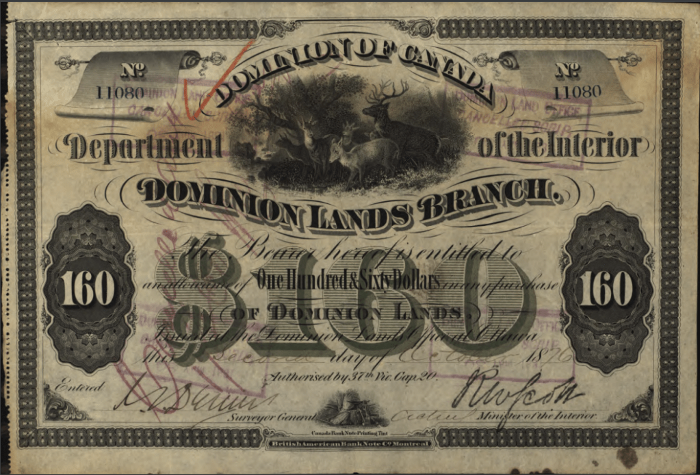
- William Bird Jr. (Great-Grandfather): Scrip No. 11076 ($160 value).
- William Bird Sr. (2nd Great-Grandfather): Scrip No. 11080 ($160 value).
- Mary Jane Bird (née Sutherland): Scrip No. 11081 ($160 value).
These were not gifts of $160. These were certificates issued by the government to extinguish their Aboriginal title. To get this paper, they had to legally sign away their Indigenous rights to the territory. They then had to use that $160 “coupon” to buy back land that the government had already taken from them. Essentially, the government was charging the Métis the full market value ($160) for land they already occupied, while offering that same land to European immigrants for a $10 processing fee.
The bureaucratic burden was immense. Long before the immigrant rush, my 2nd Great-Grandparents had to file exhaustive affidavits just to verify their right to exist on the prairies:¹¹
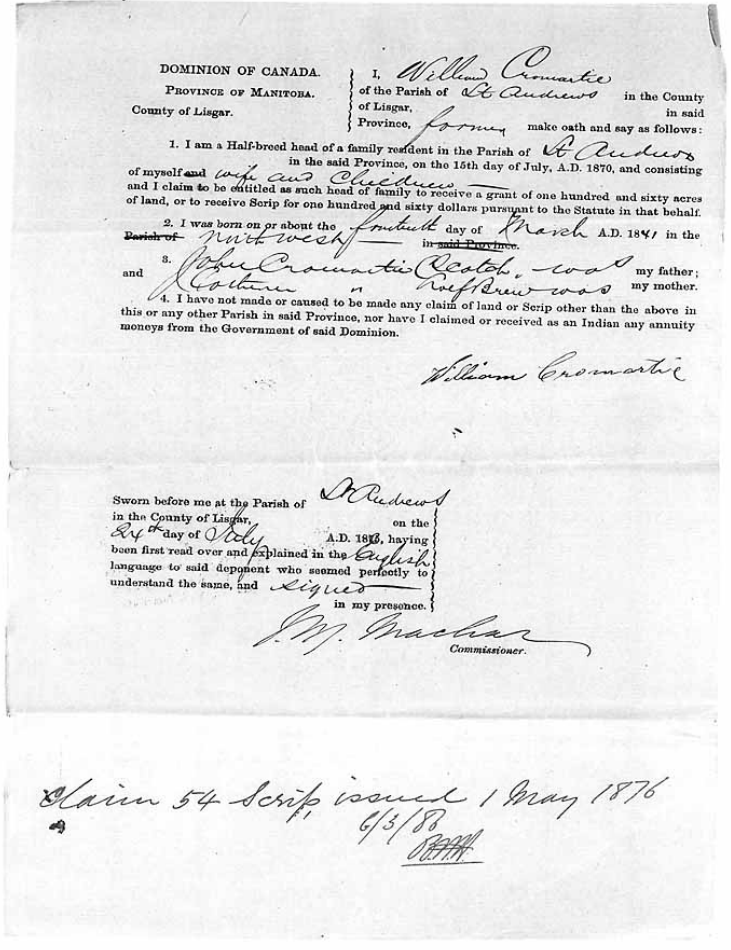
- Mary Ann Cromartie (née Hourie): Affidavit No. 60, Claim No. 55 (Issued May 1, 1876).
- William Cromartie: Affidavit No. 61, Claim No. 54 (Issued May 1, 1876).
Scrip and Affidavit Concordance
| Individual | Document Type | Certificate/Claim No. | Financial/Land Face Value | Archival Source |
| William Bird Jr. | Métis Scrip | No. 11076 | $160.00 | RG 15, Series D-II-8-c |
| William Bird Sr. | Métis Scrip | No. 11080 | $160.00 | RG 15, Series D-II-8-c |
| Mary Jane Bird | Métis Scrip | No. 11081 | $160.00 | RG 15, Series D-II-8-c |
| Mary Ann Cromartie | Scrip Affidavit | Claim No. 55 / Aff. No. 60 | $160.00 | RG 15, Series D-II-8-a |
| William Cromartie | Scrip Affidavit | Claim No. 54 / Aff. No. 61 | $160.00 | RG 15, Series D-II-8-a |
The Bragers were measured by their labor (how many acres they plowed); the Cromarties and Birds were measured by their ancestry (proving their roots through government affidavits).
Part 3: The “46A” Mystery – Displacement on Displacement
A unique detail in the family records is the designation Township 46A, where Great-Grand-Uncle William Edward Cromartie held SW-12-46A-25-W2.⁹
In the Canadian survey system, an “A” denotes a fractional township created to fill a gap or anomaly in the standard grid.¹² In this specific case, Township 46A was land carved directly out of the surrendered Chacastapasin Indian Reserve No. 98.¹³
Following the 1885 Resistance, the government claimed the Chacastapasin band had been “disloyal” and moved to break up and sell off their reserve.¹⁴ It is a sobering historical realization that while the government was displacing the Métis, the Métis were—by the very design of the Scrip system—forced onto land that had just been seized from First Nations.¹⁵ Even as they were marginalized by the homestead system, the Métis were placed in the middle of a secondary layer of displacement.
Part 4: The Marriage that Merged the Maps
In 1883, my 2nd Great-Grandparents, William Bird Sr. and Mary Jane Sutherland, arrived from Manitoba, establishing their first Saskatchewan foothold on NW-4-46-25-W2.⁶ It was here that my Great-Grandfather, William Bird Jr., grew up.
But the story of the Bird family isn’t one of outward expansion; it is a story of kinship and consolidation.¹⁶ When William Bird Jr. married Mary Jane Cromartie, he didn’t follow the “Brager Path” of traveling to a land office to claim a new, separate quarter-section for $10. Instead, he moved directly onto the Cromartie property on Section 12.¹⁷
Eventually, his parents, William Bird Sr. and Mary Jane, left their own section to join them. In total, William Bird Sr. lived on William Edward Cromartie’s farm for 44 years until William Edward’s death.¹⁷
Part 5: Kinship vs. Equity
This 44-year shared residency highlights the fundamental difference in how these two families were forced to view the “Rules of the Soil”:¹⁶
- The Brager Strategy (Individualism & Expansion): Each son filed for his own separate plot. They used the “Free Land” system to accumulate as much acreage as possible across four separate sections, building a massive footprint of financial equity that they eventually sold to fund their move to British Columbia.¹
- The Bird/Cromartie Strategy (Kinship & Endurance): In a system designed to strip them of their land through scrip speculation and high fees, they survived by pooling their resources.³ They didn’t focus on accumulating separate titles; they focused on holding down a single family farm together as a defensive unit for nearly half a century.¹⁷
Conclusion: A Tale of Two Titles
One family was playing a game of accumulation; the other was playing a game of survival. The Bragers used their land as a financial stepping stone, leaving Saskatchewan with the profits of sold titles.¹ The Birds and Cromarties left behind a 44-year legacy of shared life on a piece of land they had to defend with affidavits and certificates.¹⁷
When my Norwegian grandfather, Ingvald Brager, married my Métis grandmother, Elsie Bird, they united these two histories.¹⁸ They moved to New Westminster, BC, not just as farmers, but as a couple whose families had paid two vastly different prices for the right to call the Canadian West their home.
ENDNOTES
- Brager family land acquisitions and $10 homestead patent mechanics (Appendix D, item D1).
- Introduction of the Métis Scrip alternative to standard land settlement (Appendix D, item D2).
- The structural vulnerability and extinguishment mechanics of the Scrip System (Appendix D, item D3).
- Regional survey map breakdown for Township 46 and 46A (Appendix A, item A5).
- Local settlement dynamics of the Birch Hills/Hagen area (Appendix A, item A1).
- William Bird Sr.’s geographic homestead anchor at NW-4-46-25-W2 (Appendix A, item A2).
- John Cromartie’s land coordinate anchor at NE-12-46-25-W2 (Appendix A, item A3).
- William George Cromartie’s multi-plot land holdings (Appendix A, item A4).
- William Edward Cromartie’s fractional parcel within the former reserve boundaries (Appendix A, item A6).
- The $160 money value scrip certificates issued to the Bird lineage (Appendix B, item B1).
- 1876 Scrip Affidavits for Mary Ann Hourie and William Cromartie (Appendix B, item B2).
- Fractional township layout rules within the Dominion Lands Survey system (Appendix D, item D4).
- Boundary details and historical location of Chacastapasin Reserve No. 98 (Appendix A, item A7).
- Post-1885 structural policies regarding “disloyal” reserve asset liquidations (Appendix D, item D5).
- Shifting overlapping boundaries of Indigenous lands in Range 25 (Appendix A, item A7).
- Traditional Métis kinship consolidation patterns vs Western asset accumulation (Appendix B, item B3).
- The 44-year co-residency record of the Bird and Cromartie families on Section 12 (Appendix B, item B4).
- Marital convergence of the Brager and Bird bloodlines in British Columbia (Appendix B, item B5).
APPENDICES
APPENDIX A — GEOGRAPHIC & MOVEMENT ANCHORS
- A1. Birch Hills / Hagen DistrictThe broader regional backdrop where the Brager homesteads collided geographically with the pre-existing Métis kinship settlements. Primary; Topographical Maps; Echoes of the Past.
- A2. NW-4-46-25-W2 (William Bird Sr.)The original 1883 settlement anchor for William Bird Sr. following his family’s westward migration from Manitoba. Primary; Western Land Grants Index.
- A3. NE-12-46-25-W2 (John Cromartie)The northeast quarter-section of the core family block held by Great-Grand-Uncle John Cromartie. Primary; Saskatchewan Homestead Index.
- A4. SE-12-46-25-W2 & NE-1-46-25-W2 (William George Cromartie)The expanded holdings of William George Cromartie, sitting directly alongside the other family quarters in Section 12. Primary; Saskatchewan Homestead Index.
- A5. SE-8-46-25-W2 (Ingvald Brager)The standard $10 homestead entry belonging to Ingvald Brager, situated less than three miles west of the Bird/Cromartie family cluster. Primary; Saskatchewan Homestead Index.
- A6. SW-12-46A-25-W2 (William Edward Cromartie)The specific fractional quarter-section held by Great-Grand-Uncle William Edward Cromartie, highlighting the rare “46A” designation. Primary; Department of the Interior Survey Plans.
- A7. Chacastapasin Indian Reserve No. 98The geographical boundaries from which Townships 46A and 47A were explicitly carved following federal land seizure. Primary; Indian Claims Commission Records.
APPENDIX B — GENEALOGICAL EXTRACTS
- B1. Bird Family Scrip CertificatesArchival entries for William Bird Jr. (No. 11076), William Bird Sr. (No. 11080), and Mary Jane Bird (No. 11081), each carrying a $160 government valuation face-value. Primary; Library and Archives Canada (RG 15).
- B2. Cromartie / Hourie Scrip Affidavits1876 land-right protection declarations filed by Mary Ann Cromartie (Affidavit 60, Claim 55) and William Cromartie (Affidavit 61, Claim 54). Primary; Department of the Interior Scrip Records.
- B3. 1883 Bird Family Migration RecordDocuments tracing the movement of William Bird Sr., his wife Mary Jane Sutherland, and a young William Bird Jr. from Poplar Point, Manitoba, to the Saskatchewan North-West. Primary; Family Book Records; Census Data.
- B4. The 44-Year Co-Residency RecordLong-term household logs tracking William Bird Sr. and his wife living continuously on the William Edward Cromartie farm unit until his death. Primary; Census of Canada (1891–1911); Local Family History Logs.
- B5. Brager / Bird Marriage IndexThe official civil convergence of the Norwegian homestead lineage (Ingvald Brager) and the Métis scrip lineage (Elsie Bird). Primary; BC Vital Statistics Registry.
APPENDIX D — LAND ACT MECHANICS
- D1. The $10 Homestead FrameworkThe standard rule of the Dominion Lands Act allowing incoming immigrants clear title to 160 acres based strictly on processing fees and physical development. Secondary; The Dominion Lands Act (1872).
- D2. Aboriginal Title ExtinguishmentThe legal strategy using land and money certificates to swap future territorial or Indigenous legal rights for isolated dollar-value coupons. Secondary; Federal Scrip Commission Mandates.
- D3. Scrip Speculation DynamicsThe structural practice where unallocated paper certificates were heavily targeted by traveling land barons, buying them up from displaced families for cash-in-hand fractions. Secondary; Legal and Economic Land Histories.
- D4. Fractional Townships (“A” Survey Lines)The specialized manual instruction enabling surveyors to plot anomalous, narrow correction strips (like 46A) when standard grids hit topographical borders or seized reserves. Secondary; DLS Surveyor Manuals.
- D5. Reserve Asset Liquidation PolicyThe post-1885 federal administrative framework used to declare targeted indigenous bands “disloyal,” allowing the state to dismantle reserve boundaries and open them to non-treaty settlement. Secondary; Indian Act Amendments.
BIBLIOGRAPHY
Primary Sources
- Library and Archives Canada (Ottawa): North-West Territories Métis Scrip Applications. Record Group 15 (RG 15), Series D-II-8-c for Bird (William Jr., William Sr., Mary Jane).
- Library and Archives Canada (Ottawa): Manitoba Métis Scrip Affidavits. Record Group 15, Series D-II-8-a, Reel C-14926 for Cromartie (Mary Ann, William).
- Saskatchewan Homestead Index: Land patent files for Ingvald Brager (SE-8-46-25-W2), John Cromartie (NE-12-46-25-W2), and William George Cromartie (SE-12-46-25-W2).
- Department of the Interior: Official Plan of Township 46 and Fractional Township 46A, Range 25, West of the Second Meridian. Surveyor General’s Office, Ottawa.
- Census of Canada: Population schedules for the Northwest Territories (1891, 1901) and Saskatchewan (1911), District of Saskatchewan Forks (Birch Hills).
Secondary Sources
- Echoes of the Past: A History of Birch Hills, Hagen and Surrounding Districts: Birch Hills Historical Society, Birch Hills, Saskatchewan, 1990.
- The Dominion Lands Act (1872): Federal legislative framework for Western Canadian homestead surveying and settlement.
- James Smith Cree Nation: Chakastaypasin Inquiry (IR 98) Report: Indian Claims Commission, Government of Canada, 2005.
- Manual of Instructions for the Survey of Dominion Lands: Dominion Lands Survey Branch, Government Printing Bureau, Ottawa, 1910.


 tilixam
Leave a comment