To visualize the massive influence of James Curtis Bird, one must look at the specific geometry of his estate in the Red River Settlement. While most settlers’ lots were narrow ribbons restricted by the strict “Two-Mile Limit,” Bird’s grant broke every standard rule of the era.
From “Squatter” to Landowner: Lot 754 and Lot 95
The history of this land is reflected in the changing administrative records of the colony. In the 1827 Red River Census, James Curtis Bird is listed as residing on Lot 754.¹ at this time, he was already established on his massive estate with a house, barn, 12 oxen, and 16 acres under cultivation.²
However, Lot 754 was part of an early, temporary numbering system used for tax and census purposes. Because the settlement had not yet been formally “mapped” for permanent land titles, Bird was effectively occupying the land promised to him by the Hudson’s Bay Company (HBC) until a formal survey could be completed.³
The definitive legal designation came with the George Taylor Survey of 1836–1838.⁴ The HBC commissioned Taylor to create a permanent “Cadastral Plan” to register land grants formally in Land Register B. During this survey, the entire settlement was re-numbered from north to south, and James Curtis Bird’s 3,000-acre estate was officially registered as River Lot 95 in the Parish of St. Paul.⁵
Mapping Lot 95: Breaking the “Two-Mile Limit”
When the Selkirk Treaty was signed in 1817, it defined the colony’s boundaries as the distance a person could see “under a horse’s belly”—roughly two miles from the riverbanks.⁶ Most lots were surveyed to end exactly at this point.
James Curtis Bird’s Lot 95 was an extraordinary exception. Located on the east bank of the Red River, his property did not stop at the two-mile mark; it was extended an additional two miles back into the prairie, for a total depth of roughly four miles (6.4 kilometres).⁷
The Strategic Geography of “Birds Hill”
This extra depth allowed the property to encompass the elevated terrain of a glacial esker—a rare high point in the flat Red River Valley.⁸
- The 1826 Flood Sanctuary: During the catastrophic flood of 1826, your 4th great-grandfather’s land became a literal lifesaver. Most of the colony’s inhabitants and their livestock fled to the high ground of what was then Lot 754 to survive.⁹
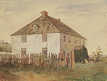
- The “White Cottage”: Bird built a substantial home on the riverfront portion of the lot, known as the “White Cottage.” From this estate, he operated as a “principal settler” and a member of the Council of Assiniboia.¹⁰
Modern Landmarks: Tracing the Bird Estate
Today, it is the Lot 95 designation that is used by historians and park rangers to define the boundaries of the Bird legacy.¹¹ You can still see these boundaries through modern landmarks:
- Birds Hill Provincial Park: Much of the park occupies the eastern portion of the original Lot 95.⁷
- The Town of Birds Hill: Located southwest of the park, the town directly bears his name.¹
- Pine Ridge: The Bird family referred to the higher, forested area of their lot as “Pine Ridge,” a name that survives today as a community southeast of the park.¹²
Endnotes
- “James Curtis Bird (1773–1856),” Red River Ancestry, www.redriverancestry.ca.
- “1827 Red River Census – James Bird,” Archives of Manitoba, MG2 B3.
- “Red River Settlement Land Records,” Canada’s History, www.canadashistory.ca.
- “The Taylor Survey,” The Virtual Museum of Métis History and Culture, www.metismuseum.ca.
- “Land Register B: River Lot 95,” Hudson’s Bay Company Archives, Archives of Manitoba.
- Alexander Morris, The Treaties of Canada with the Indians of Manitoba and the North-West Territories (Toronto: Willing & Williamson, 1880).
- “Birds Hill,” Red River North Heritage, redrivernorthheritage.com.
- “Geology of Birds Hill,” Manitoba Parks and Protected Spaces, www.gov.mb.ca.
- “Site 13: Bird’s Hill,” Red River North Heritage, redrivernorthheritage.com.
- John E. Foster, “Bird, James (James Curtis),” in Dictionary of Canadian Biography, vol. 8 (University of Toronto/Université Laval, 1985), www.biographi.ca.
- “The Lot 95 Designation,” Manitoba Historical Society, www.mhs.mb.ca.
- “Pine Ridge Community History,” WikiTree, www.wikitree.com.

Leave a comment